










By Editorial Team · Updated July 9, 2026
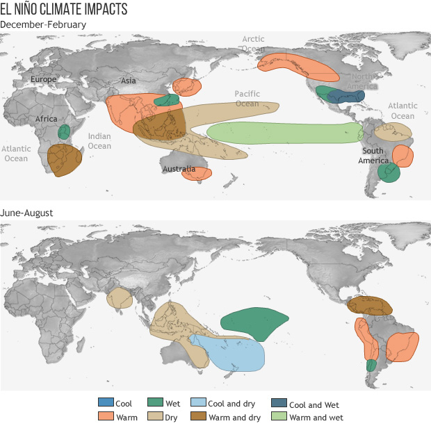
El Nino in India isn’t just a term you hear in weather reports—it’s something that can shape your food prices, your water supply, and even your daily routine. As the Pacific Ocean warms, India’s 2026 southwest monsoon has already stalled, leaving a nationwide rainfall deficit and below‑average rains expected through September, according to the India Meteorological Department (IMD). You’re seeing the effects in delayed sowing for farmers and water cuts in big cities like Mumbai. But how exactly does a shift in the equatorial Pacific end up drying out your fields—or triggering intense downpours in some regions?
El Nino in India
IMD reports El Niño conditions and dry northwest winds have stalled the 2026 southwest monsoon, causing a 42% all‑India rainfall deficit by late June. IMD and international agencies link El Niño conditions to a high risk of below‑average monsoon rainfall over India in 2026. Research and official data show El Niño often weakens India’s overall monsoon but can increase the odds of extreme daily rainfall in some regions.
How Developing Pacific El Niño Conditions Are Disrupting India’s 2026 Monsoon
You’re seeing the current Pacific warming pattern play out in real time in 2026, as conditions in the equatorial ocean reshape how, when, and where the southwest monsoon delivers rain.
A Stalled Monsoon and a Sharp Early-Season Deficit
By late June 2026, IMD data show the monsoon’s normal march across the country has been slowed by two linked drivers:
- El Niño conditions over the equatorial Pacific
- Dry northwesterly winds cutting off moisture supply into peninsular and central India
Together, these have produced an all‑India rainfall deficit of 42% for the season to date, with weak, patchy showers where you’d usually expect sustained rain.
Official Forecasts Flag a Weaker Season
IMD’s long‑range assessments connect the dots between the Pacific pattern and the full June–September outlook:
- El Nino conditions in the equatorial Pacific
- Historical tendency for sub‑normal monsoon totals in such years
- An expectation that 2026 rainfall will stay below the long‑period average
A Hindustan Times summary of an ESSO–IMD bulletin notes these Pacific conditions are already “active” and likely to strengthen as the season progresses, boosting the odds that the deficit you see now doesn’t fully recover.
| Driver | Effect on 2026 Monsoon Over India |
|---|---|
| Warming equatorial Pacific | Weakens monsoon circulation into the subcontinent |
| Strengthening El Niño episode | Raises risk that seasonal rainfall stays below average |
IMD and WMO Forecasts: What Below‑Normal Rainfall Means for June–September 2026
You’re now seeing how forecasts around this Pacific‑driven pattern are shaping expectations for the rest of the 2026 monsoon, especially after IMD reported a sharp early‑season rainfall deficit and a stalled southwest current.
What IMD Is Actually Predicting
IMD’s long‑range guidance for June–September 2026 points to:
- All‑India rainfall below the long‑period average
- A stronger‑than‑usual influence from Pacific warming
- The possibility that this season’s rainfall could end up lower than any of the last three years, as highlighted by IMD’s Director‑General
To build these outlooks, IMD draws on its historical table of monsoon departures in earlier warm‑phase years, which shows many past seasons ending with negative anomalies.
How WMO and Other Agencies See the Same Risk
The World Meteorological Organization and other global centers echo IMD’s concern:
- WMO assessments give about an 80% chance that Pacific warming will be in place through June–August 2026.
- A NOAA ENSO update summarized in Indian media suggests these conditions could persist to the end of 2026, keeping the background risk of a weaker monsoon elevated.
- India’s Ministry of Earth Sciences has told Parliament that these Pacific phases significantly influence India’s monsoon rainfall patterns and associated drought and flood impacts, reinforcing why below‑normal rainfall is being treated as a real planning scenario.
Impacts on Agriculture, Water Supply and Urban Life During the Delayed Monsoon
When you feel the effects of this event during a slow‑moving monsoon, they tend to show up first in the fields, then in your taps, and finally in how your city functions day to day.
Farm Decisions Under a 42% Rainfall Deficit
With early‑season rains running far below normal, you face awkward choices about sowing:
- Delayed planting: Kharif crops like rice, pulses and oilseeds may have to wait for a reliable wet spell, squeezing the growing window.
- Switching crops or varieties: You might shift to shorter‑duration or less water‑demanding options if you fear the season will stay dry.
- Higher input risk: Every bag of seed or fertilizer you buy feels riskier when you cannot depend on timely showers.
These shifts can ripple into lower yields, patchy crop growth and higher costs for irrigation where groundwater or canal water is still available.
Water Supply Strain and Urban Restrictions
In cities, the weak, scattered rain that experts have linked to the current Pacific warming quickly shows up as:
- Stricter timing and pressure cuts in piped water
- More dependence on tankers and private borewells
- Stress on shared sources, especially where reservoirs missed early inflows
Mumbai’s recent restrictions highlight how fast large metros can tighten rules when inflows lag.
Urban Life: Heat, Infrastructure and Sudden Downpours
A delayed monsoon often means you endure prolonged heat in concrete‑heavy neighborhoods, followed by episodes of sharp rain that can overwhelm drains. Research shows such intense bursts are more likely over parts of central‑eastern India and the southwest coast, so even in a season of overall shortage, you still have to plan for both water scarcity and disruptive local flooding.
Historical El Niño Years and Long‑Term Links to Weak Indian Monsoon Rains
When you look back across more than a century of records, the story of this phenomenon over India is one of repeated, though not guaranteed, hits to the summer monsoon.
What IMD’s Historical Records Show
IMD maintains a detailed table comparing all‑India monsoon rainfall with years when El Niño was active. When you scan that dataset, you see a clear pattern: many of the El Niño years line up with negative rainfall departures from the long‑period average (LPA). In plain terms, a large share of these years delivered below‑normal monsoon rains.
A simplified snapshot of what the IMD table demonstrates:
| Indicator | Typical signal in El Niño years* |
|---|---|
| All‑India seasonal mean rainfall | Often below LPA |
| Drought risk | Frequently elevated |
\*Based on IMD’s historical El Niño–ISM (Indian Summer Monsoon) dataset.
From Historical Pattern to Policy and Risk Planning
A Government of India submission to Parliament notes that IMD has formally studied these links and confirmed that both El Niño and La Niña exert a strong influence on India’s monsoon rainfall patterns and related drought and flood impacts. This is one reason seasonal outlooks now factor these ocean conditions into early warnings for agriculture, reservoirs, and disaster management.
If you want to dig into the scientific background yourself, you can explore the Ministry of Earth Sciences’ documentation on monsoon variability and ENSO influences here.
Changing Risk of Extreme Rainfall Events Over India in an El Niño‑Influenced Climate
Fewer Total Rains, But More “Cloudburst” Days
You might expect a weaker monsoon to simply mean less rain everywhere, but recent research on India’s long‑term rainfall records shows a sharper twist: during El Niño summers, the season’s average rain drops, yet the odds of single days with very intense downpours go up in some regions. A peer‑reviewed study using data from 1901–2020 finds that this contrast is especially strong over central–eastern India and parts of the southwest coast, where short, violent spells become more likely even in below‑normal seasons.
In other words, you face both drought stress over weeks and flash‑flood danger on particular days.
Where the Risk Is Shifting
Based on that long record, the pattern looks like this:
| Region (broad) | Seasonal rain in El Niño years | Daily extremes in El Niño years |
|---|---|---|
| Central–eastern India | Often reduced on average | Higher chance of extreme days |
| Southwest coastal belt | Often reduced or near normal | Higher chance of extreme days |
For you, this means:
- Farmers may see dry spells during key crop stages, then sudden storms that erode soil and waterlog fields.
- Towns and cities can go from water rationing to flooded streets within a single week.
- Dam and reservoir managers must juggle low storage with the risk of abrupt inflow surges.
Government analyses recognize that Pacific‑driven climate cycles can swing India between droughts and floods in the same season, and ongoing El Niño conditions keep that double‑edged risk firmly in play.
Frequently Asked Questions
How does El Niño in India actually disrupt the usual monsoon wind pattern?
You normally rely on moist winds from the Arabian Sea and Bay of Bengal to bring steady rain across the country. During El Niño, abnormal warming in the equatorial Pacific can weaken or shift these monsoon winds, so they deliver less moisture and more “breaks” in the rain, even if clouds still form at times.
Why can you get both weaker total rainfall and more extreme downpours in some regions?
El Niño tends to reduce the season’s average rainfall over India, but that doesn’t mean every day is dry. Studies using long‑term data show that when the large‑scale monsoon weakens, some systems still intensify locally, so you can see more days with very heavy cloudbursts over central‑eastern belts and parts of the southwest coast even while the overall seasonal total is lower.
If you’re a city resident, what early signs should you watch for during an El Niño‑affected monsoon?
You’ll often notice delayed onset, longer dry spells between showers and stricter water‑supply schedules before official drought declarations appear. Keeping an eye on IMD’s weekly monsoon progress updates and local reservoir levels helps you adjust your water use and daily routines before restrictions become severe.
How can farmers and urban planners use seasonal forecasts linked to El Niño more effectively?
Instead of treating the forecast as a precise prediction for your village or neighborhood, use it as a risk signal for the whole season. Farmers can stagger sowing dates or diversify crop choices, while city planners can time reservoir releases and maintenance work so they’re better prepared for both prolonged dry periods and short, intense rain episodes.
What long‑term lessons should you draw from repeated El Niño impacts on India?
Taken together, the historical record and recent research show that these Pacific events systematically tilt the odds toward weaker monsoon rains, with a higher chance of local extremes. For you, that means planning ahead—whether in farming, water management or city living—so each new episode of this phenomenon over India feels challenging, but not unexpected or unmanageable.
Sources
- apnews.com
- ndtv.com
- indiatoday.in
- indiatoday.in
- indianexpress.com
- hindustantimes.com
- mausam.imd.gov.in
- moes.gov.in
- arxiv.org